INTRODUCING iXL
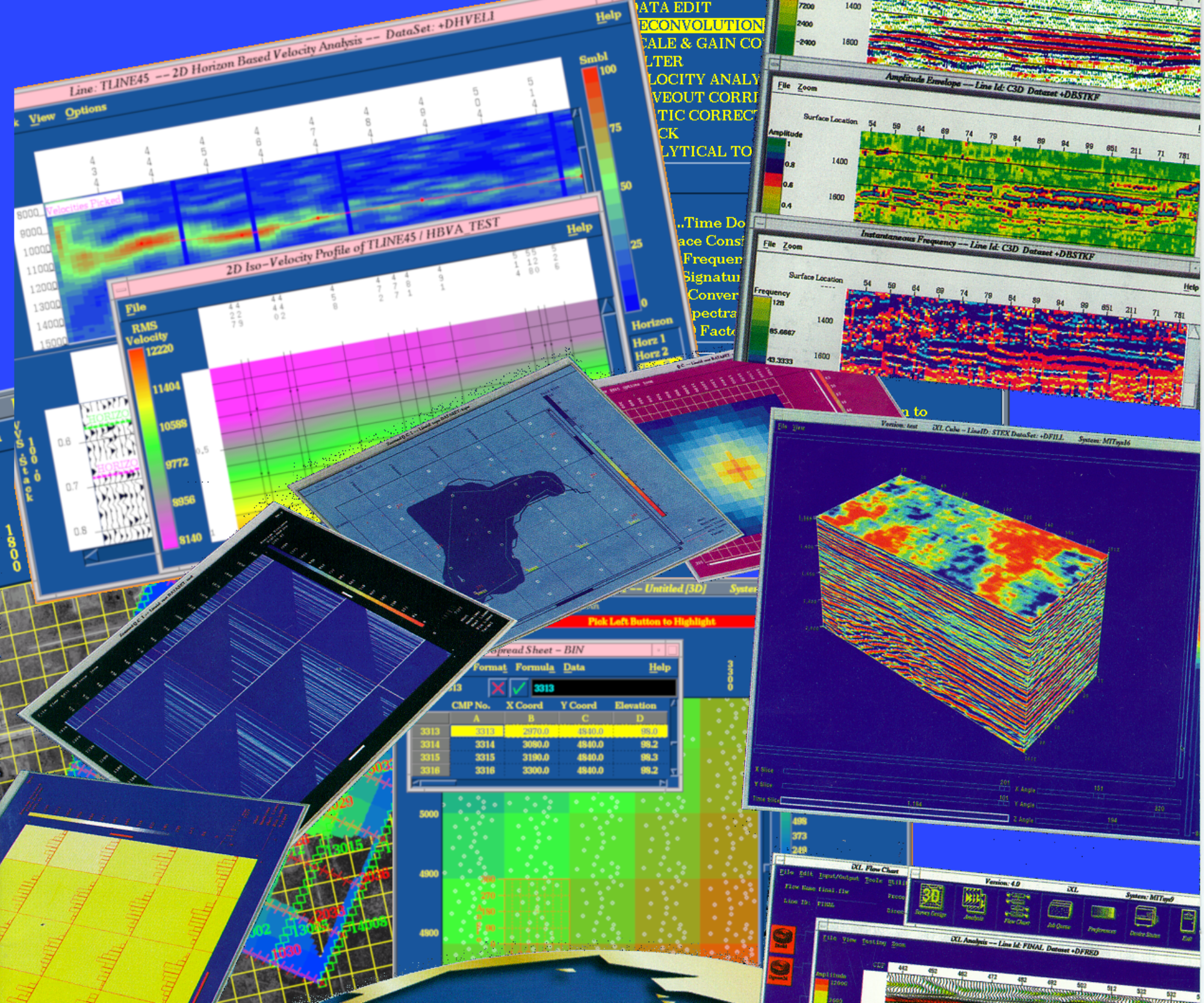
iXL is the most comprehensive and highest performance to cost value 3D and 2D, interactive and batch commercial seismic software package available. iXL gives superior performance in the field on laptops or in the office utilizing powerful Linux workstations. iXL follows our own internal programming standards to produce an intuitive, user-friendly interactive interface with rapid high resolution graphics. Users can enjoy interactive seismic data analysis and processing in a mouse-driven point-and-click environment. iXL is equipped with a full range of 2D and 3D seismic processing software from survey design through one-pass 3D post-stack migration.
Developer
Ralph Gobeli has spent his career working at the intersection of seismic imaging and high-performance computing. Early in his career—when seismic processing was among the largest consumers of computational power in the world—he focused on the practical problem of transforming massive volumes of raw seismic data into reliable images of the subsurface.
Mentored by signal-processing pioneer Sven Treitel, Ralph worked on the development and implementation of advanced seismic algorithms, including adaptive filtering, F-X-Y deconvolution, and transforms based on Fourier, Hilbert, Radon, and Tau-p methods. His work emphasized both algorithmic rigor and computational efficiency, often reducing processing times from months to hours on large supercomputing systems such as Cray, SGI, and Fujitsu platforms.
Building on that experience, Ralph led the development of iXL, a commercial seismic processing system designed to bring advanced 2D and 3D seismic analysis into an integrated working environment. Rather than separating algorithm development from day-to-day interpretation work, iXL was designed so geophysicists could interact directly with processing workflows, visualize results quickly, and iterate on complex datasets.
Across his work in seismic computing, Ralph has maintained a consistent focus on making complex computational methods both faster and more usable for the scientists who rely on them. Below are some of his major contributions to the field of seismic processing:
TECHNICAL PAPERS
Ralph Gobeli (LinkedIn: ralph-gobeli)) — Research timeline / key contributions
3-D Seismic Survey Design As an Optimization Problem (SEG 1998, OnePetro)

https://onepetro.org/SEGAM/proceedings/SEG98/SEG98/SEG-1998-0117/86512 (OnePetro)

3-D seismic survey design as an optimization problem (The Leading Edge, DOI)

https://doi.org/10.1190/1.1438430 (Crossref Chooser)

3-D seismic survey design and linear v(z) (SEG 1997 Expanded Abstracts, DOI)

https://doi.org/10.1190/1.1885927 (Geoscience World)

Bin size and linear v(z) (SEG 1996 Expanded Abstracts, DOI)

https://doi.org/10.1190/1.1826680 (Geoscience World)

DMO Amplitude (SEG 1995, OnePetro)

https://admin.onepetro.org/SEGAM/proceedings/SEG95/SEG95/SEG-1995-1437/85298 (admin.onepetro.org)

Sloping event DMO amplitude (EAGE / EarthDoc, DOI)

https://www.earthdoc.org/content/papers/10.3997/2214-4609.201408884 (earthdoc.org)

Depth focusing reflection tomography with application to prestack depth migration (SEG 2000, DOI)

https://doi.org/10.1190/1.1816224 (Geoscience World)

Minimum Phase Signal Shaping with the Double Least Squares Algorithm (EAGE / EarthDoc)

https://www.earthdoc.org/content/papers/10.3997/2214-4609-pdb.131.GEN1997_A027 (earthdoc.org)

Geophysics and the Internet (2000, The Leading Edge)

https://pubs.geoscienceworld.org/seg/tle/article-abstract/19/8/877/59114/Geophysics-and-the-Internet (Geo Science World)
PAPERS CITING THE PUBLICATIONS
3D seismic survey design optimization (Vermeer, PDF)

https://3dsymsam.nl/wp-content/uploads/2016/02/Optimization.pdf

Bi-objective optimization for seismic survey design (Monsegny, GeoConvention 2018, PDF)

https://www.crewes.org/Documents/ConferenceAbstracts/2018/CSEG/Monsegny_CSEG_2018.pdf

Proposta metodológica de otimização… sísmica terrestre 3D (Porsani et al., PDF)

https://www.researchgate.net/profile/Milton-Porsani/publication/259678606_Proposta_metodologica_de_otimizacao_de_parametros_de_aquisicao_de_sismica_terrestre_3D_Aplicacao_nas_bacias_sedimentares_brasileiras/links/00b7d52ffbf4272b90000000/Proposta-metodologica-de-otimizacao-de-parametros-de-aquisicao-de-sismica-terrestre-3D-Aplicacao-nas-bacias-sedimentares-brasileiras.pdf

Optimized Experimental Design in the Context of Seismic Full Waveform Inversion (ScienceDirect chapter page)

https://www.sciencedirect.com/science/chapter/bookseries/pii/S0065268717300018
SURVEY DESIGN
Versatile software for geometry setup, analysis, and quality control for both pre- and post- survey geometries. Utilizing a powerful graphic interface, users can define all the necessary geometry parameters with ease and efficiency. Survey quality control using attribute overlays in conjunction with cultural and geological model information on the land grid provides unparalleled confidence in a survey geometry. Of course, UKOOA and SEGP1 format files can be input for the geometry definition. The same module is used for both land and marine surveys in 2D and 3D.
TRACE INDEXING
Using the Trace Indexing feature, the user can readily obtain common-shot, common-receiver, CMP, or any sort order records from any pre-stack disk data set. Data can be resorted, sifted, or limited on any user-specified header words.
3D DATA VOLUME DISPLAY
The 3D Data Cube Display is an innovative method of viewing, selecting, and performing quality control on your 3D data volume.
ADVANCED GEOPHYSICAL TECHNOLOGY
iXL has a wide variety of advanced technology analysis algorithms, such as AVO analysis, Tau-P Transform, Random Transform, F-X Deconvolution, 2D Pre and Post Stack Migration, 3D non-aliasing DMO, 3D singles pass Post Stack Migration and many others.
INTERACTIVE PROCESSING
iXL offers both interactive and batch processing modes. By using the interactive mode, parameter tests and data analysis are performed on-screen to obtain the optimum processing parameters. Processing flows for the batch mode are set up and modified graphically with great ease.
INTERACTIVE VELOCITY ANALYSIS
iXL provides truly interactive 2D and 3D velocity analysis, giving the best stacking velocity manipulation such as velocity map utilities including Cubic Display of your 3D Velocity Model.
BUILT-IN REMOTE ACCESS
iXL includes a built-in copy of ThinAnywhere to allow remote access to your seismic processing and survey design. Collaborate with processors at remote locations or allow your customers to view the progress.
FINAL DISPLAYS
iXL can produce high quality professional final paper or film displays with comprehensive annotations, including velocity boxes, line intersections, well locations, and side label containing all the pertinent processing information.
iXL IS COST EFFICIENT!
iXl allows multiple users per CPU, AT NO ADDITIONAL FEE. iXL provides an excellent development environment for our clients’ proprietary algorithms and integration with other vendor’s products.
EXPERIENCED CUSTOMER SUPPORT
iXL can tailor the amount of customer support you receive to your needs. It can include technical inquiries, software maintenance, and training. Experienced professionals are dedicated to providing the best solutions for our clients.
CONTACT US FOR MORE INFORMATION AND A FREE DEMO
